
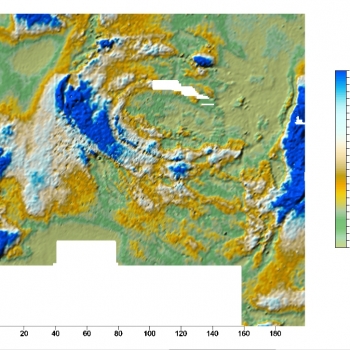
In the spring of 2014 the settlement complexes at Skomack Wielki (Ostrów) and Szurpiły were subjected to a non-destructive geophysical survey using the resistivity method led by G. Kuś. The aim of this study was investigating subsurface archaeological deposits in two areas designated within each complex.
The resistivity survey, one of a group of geo-electrical methods, is the recording of electrical parameters of layers found in an archaeological site. It helps determine the distribution of resistance in the studied area. The resistivity of individual locations may vary depending on their geology and moisture levels. Thus, it is possible to identify within a studied site areas with different resistivity values, which may confirm the presence of archaeological features. Data obtained from the resistivity survey were expected to facilitate the detection of the remains of subsurface archaeological features and structures associated with the functioning of the centres at Skomack Wielki and Szurpiły in the past.
At Skomack Wielki (Ostrów) the resistivity survey covered a total area of approximately 3.3 ha, at Szurpiły – approximately 3.1 ha. The equipment used were ADA-GK meters, by ELMES, and RM 15D Advanced, by Geoscan Research. The survey was made using the Wenner array and a system of two electrodes.
The data obtained helped identify anomalies which may be safely attributed to the presence of archaeological features (e.g., linear anomalies corresponding to the construction of the earthworks of the hillfort at Skomack Wielki (Ostrów). Another group of anomalies are likely to correspond to the presence of archaeological features. The interpretation of the recorded anomalies needs to be confirmed by archaeological excavation.